


Super Niño 2026: Between science and sensationalism

Amid headlines warning about a possible “super El Niño” in 2026, the scientific community is urging caution. The term, while attention-grabbing, is not part of the official language used by leading meteorological agencies.
The National Oceanic and Atmospheric Administration, through its Climate Prediction Center, avoids such labels and instead classifies El Niño events as weak, moderate, strong, or very strong based on the level of warming observed in the equatorial Pacific Ocean.
According to the center’s latest report, the ENSO system — which includes both El Niño and La Niña — is currently in a neutral phase. However, climate models indicate a probability of more than 60% that El Niño will develop between late spring and summer of 2026, with the potential to persist through the end of the year.
Even so, experts emphasize that these forecasts should be interpreted with caution. Predictions issued during the boreal spring are typically the least reliable due to what is known as the “spring predictability barrier,” a period when climate models tend to show greater variability and reduced accuracy.
As a result, current projections could change significantly in the coming months, including the eventual strength of the event.
Beyond the inherent uncertainty in forecasts, current oceanic and atmospheric conditions are already showing meaningful signals. These include the gradual warming of waters in the equatorial Pacific, the presence of wind anomalies — particularly westerly winds — and the buildup of heat beneath the ocean surface.
This combination of factors is characteristic of the early stages of El Niño events that, in past decades, have evolved into moderate or even strong episodes, underscoring the need for continued monitoring in the months ahead.
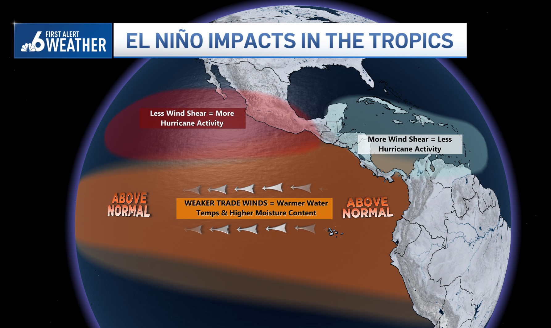
El Niño is a climate phenomenon defined by the abnormal warming of sea surface temperatures in the tropical Pacific, which disrupts global atmospheric circulation and alters patterns of rainfall, temperature, and storm activity around the world.
In South Florida, its effects are especially noticeable during hurricane season. The presence of El Niño typically increases wind shear over the Atlantic, a condition that makes it more difficult for tropical cyclones to form and intensify. This generally leads to less active hurricane seasons, although it does not eliminate the risk of significant impacts if storms do develop.

Adding to this scenario is a broader climate factor that concerns scientists. Sea surface temperatures across much of the global ocean remain above historical averages. This widespread warming, linked to climate variability and long-term climate change, can amplify the effects of phenomena like El Niño by enhancing temperature anomalies and increasing the likelihood of extreme events.
In this context, even a moderate El Niño could produce more pronounced impacts than similar events in the past.
Despite the growing use of the term “super El Niño” in some media coverage, experts agree that it is an oversimplification that can lead to misunderstanding.
The current scientific evidence points to a potential El Niño developing in 2026 that could be significant, but is still subject to important changes in the coming months. For that reason, the guidance remains clear: follow official updates closely and avoid premature conclusions, especially during this time of year when uncertainty remains a defining factor in climate forecasting.
What's Your Reaction?
 Like
0
Like
0
 Dislike
0
Dislike
0
 Love
0
Love
0
 Funny
0
Funny
0
 Angry
0
Angry
0
 Sad
0
Sad
0
 Wow
0
Wow
0


